|
DYNAMIC STRATIGRAPHY WORKGROUP |
|
Publications and presentations: Publications Olariu M. I., Olariu C., Steel J. R., Dalrymple R. W. and Martinius A. W., 2010, Anatomy of a laterally migrating tidal bar: Esdolomada Member, Roda Formation, Graus-Tremp Basin, Spain, in review at Sedimentology
Conference/meeting presentations Olariu M. I., Olariu C., Steel J. R. and Martinius A., 2009, Characteristics of obliquely migrating tidal bars: Esdolomada Member, Roda Formation, Graus-Tremp Basin, Spain, AAPG Annual Meeting, Denver |
|
People: Mariana I. Olariu, Ronald J. Steel, Cornel Olariu Research question(s): This study documents the facies and architecture of a laterally-accreting ancient offshore tidal bar in the Lower Eocene deposits of Roda Formation in the Tremp-Graus Basin in the south-central Spanish Pyrenees. Tidal bars and dune complexes of ancient deposits have received little attention despite the importance of these morphological elements in modern tide-dominated environments and their significant reservoir potential in ancient successions. Both tidal bars and dune complexes have been described from modern environments, but have not been widely used as analogs for ancient deposits. Tidal bars, in contrast to equally large compound dunes, accrete laterally with respect to the net sediment transport direction. However, it can be difficult to distinguish laterally accreting tidal bars from downstream accreting compound dunes of equivalent height and similar facies, in ancient outcrops with only 2-D exposures. As a result, dune complexes can be easily misinterpreted as tidal bars in ancient deposits. We demonstrate in this study how this distinction is made in the field. Through this study we try to understand the depositional processes and geometry of tidal bars which are important for predicting their extent and internal architecture, findings that will be useful for reservoir modeling. |
|
Characteristics of obliquely migrating tidal bars: Esdolomada Member, Roda Formation, Graus-Tremp Basin, Spain |
|
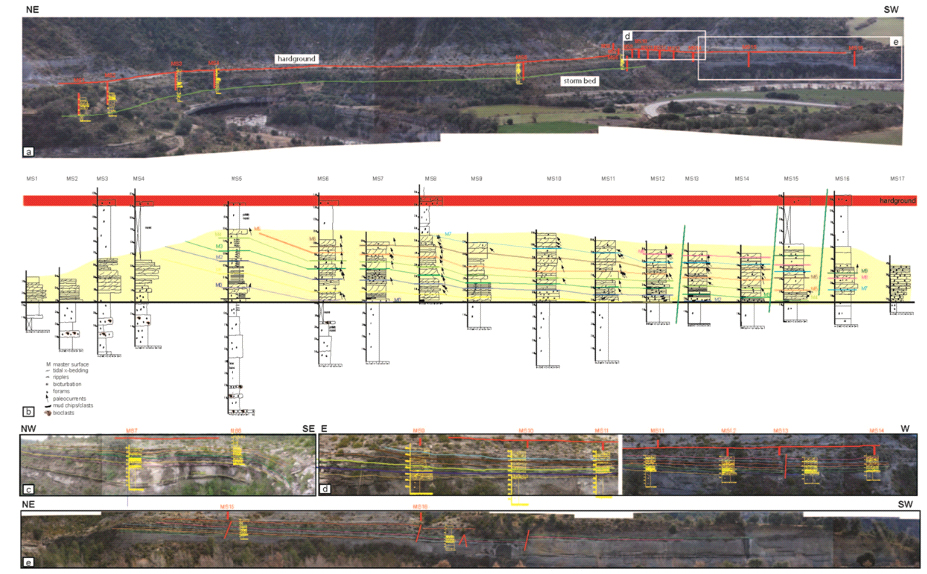
Summary of work: LIDAR (Light Detection and Ranging), photomosaics and vertical measured sections (17) have been used to characterize the architecture of the Esdolomada 1 sandbody. Multiple scans taken from various locations (different angles) are integrated using Polyworks software. Key stratigraphic features such as bedding planes and facies boundaries are highlighted on the 3-D terrain model of the outcrop and their orientation (strike/dip) determined. Lateral continuity and morphology (variability of bed thickness) of sedimentary bodies in three dimensions allowed the architecture of the tidal bar to be reconstructed. The strike and dip of both dune foresets and master bedding surfaces were corrected for the regional structural dip, using the underlying storm bed (N50.5E/4˚) as a reference horizon. The Esdolomada 1 sandbody of the Roda Formation has been interpreted as a tidal bar developed on the shelf within the Tremp-Graus gulf or embayment. The bar has an exposed width of 1700 m, a preserved height of about 5.5 m and is made up of stacked sets and cosets of medium-grained, cross-stratified sandstone; mud drapes are thin and rare; salinity was normal marine and bioturbation ranges from moderate to high in the younger strata. Cross-stratal set thickness decreases laterally on the downlapping master surfaces and the degree of bioturbation increases, so that the cross-bedded sandstones gradually pass into highly bioturbated finer-grained and thinner-bedded sandstones lacking any cross-stratification. The rate of thinning of the lateral-accretion growth increments in the bar is some 40 cm per 100 m (0.004) for the older, thicker sandstones, whereas the younger, thinner beds thin at a rate of 15 cm over 100 m (0.0015). The bar commonly has a sharp base and top; its length (crest orientation) is oriented NW-SE almost parallel to the tidal paleocurrents and to the paleoshoreline, but it accreted laterally towards the SW through time. |
|
Outcrop interpretation based on photomosaics and stratigraphic measured sections. A) Outcrop photo mosaics showing the positionsof the stratigraphic columns (MS1-MS17) along the 1.5 km outcrop. Field observations and measurements were concentrated on the stratigraphic interval betweenthe storm bed below the tidal bar and the hardground above. B) Correlation panel based on stratigraphic columns. Note that vertical logs are not spaced according to their true locations. Master bedding surfaces M1-M9, identified and quantified on LIDAR and photomosaics are interpreted on the measured sections. Outcrop photomosaics of c) the left side of gully, d) the right side of the gully, e) the southernmost part of the outcrop with superimposed bedding diagrams and stratigraphic columns. |